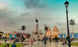
Our journey to Cusco began in Ica where we took the 7 PM overnight bus. It’s an 18-19 hour journey so I’d recommend getting a VIP seat which is comfier and reclines further back. I slept for most of the journey and got off to stretch my legs whenever the bus stopped for short breaks. We arrived at the Cusco Bus Terminal around 1.30 PM. We were staying in the area of San Blas, 3 blocks from the main square Plaza de Armas. It was a 30-minute walk, so with the blazing sun and heavy backpacks, we opted to take an Uber1. The ride took about 15 mins with some traffic and cost 8 PEN2. After unpacking and resting for a bit, we went to check out the city and look for tours. We decided on a full-day tour of the Valle Sagrado for the following day. The tour we got was for transportation with a guide for 75 PEN each. Ticket costs were then the Partial Ticket of the Valle Sagrado at 70 PEN each and the Salineras de Maras ticket at 10 PEN each which you pay at the corresponding sites. We also booked a Rainbow Mountain Tour – which included lunch – for when we returned from Machu Picchu at 65 PEN each. Once the tours were sorted out, we headed to the Plaza de Armas for some dinner. There are several restaurants in the square and the staff is outside tries to get people to come in. We chose a restaurant with a first-floor window view to catch the sunset. Next, we went to grab some snacks for the following day before heading back to our room to get some sleep.

Chinchero
It’s an early start for this tour with the minibus picking us up at 7 AM. After touring around the city to pick everyone else up, we made our way to the first destination – Chinchero. The journey from Cusco to Chinchero is about an hour. We first stop at an arts and crafts workshop where one of the indigenous women talk through the process of making their textile products. Following the talk, we’re given about 10 minutes to browse around to make any purchases. Next, we get back on the minibus and continue for about 5 minutes to the site. We start at the main plaza outside the town’s church where indigenous people are setting up for a small market. The guide said that on Sundays, there was a big market in the main plaza. The tour guide then gives a brief history of Chinchero and the people who used to live there before the Incas took over. We then walk deeper into the town and come across the agricultural terraces. The tour guide then explains how their stepped design was used to create microclimates, enabling them to grow a wider variety of crops. She also talks about how all the terraces are layered with large stones at the base, sand in the middle, and fertile earth on top which facilitates filtration. We’re given about 10-15 minutes to explore the area and take pictures. We then head back to the main plaza and are given 10-15 minutes to explore the church. Then it’s back to the minibus and onwards to the next destination.


Moray
From Chinchero, it takes about 50 minutes to get to Moray. This site showcases several circular agricultural terraces of the Inca Empire. The guide talks about how these circular forms were less common and although their purpose is not known, they are believed to have been used for research by the Incas. The guide goes into a bit more detail about micro-climates and how the Incas experimented with crops and vegetation. We were given about 20-30 minutes to roam around the site and take pictures before heading back to the bus.


Salineras de Maras
It takes about 40 minutes to get to the Salineras de Maras from Moray. Just past the entrance, there is a great viewpoint of the salt mines which are stacked along the mountainside. The guide gives a history of the salt mines which predate the Incas and also talks about how they form. She mentions that salt mines can only be mined by the local community and each plot belongs to a family member of the community. There is a trail that goes along the plots of salt deposits. The path is very narrow so it is a one-way circuit that loops back. Now that it was later in the day, there were many more tourists at this site compared to the previous two. You’ll find that traffic stops on the trail when people are taking pictures, so oftentimes you’ll be waiting for the line to move. Overall, there are several viewpoints with great panoramic views of the salt mines.


Ollantaytambo
This next stop is about an hour away from the Salineras de Maras. Once you enter the site, you’ll see the familiar terraced structures built into the mountain. However, unlike the previous destinations, Ollantaytambo had a military purpose. We walk up to one of the terraces where we sat down in some shade for the guide to give us information on the site. She goes over the details of the structure and points out the high walls which force attackers to go up through a narrow passage. She also goes over its strategic location and gives a history of its use and construction. She said that construction was never fully completed due to a civil war that followed after Huayna Capac died leaving no successor – which she goes over in more detail. After the discourse, we were given about 30 minutes to explore the site. We continued to the top of the hill where there were some reconstructed structures. There is another trail that starts there which seems to go around behind the mountain but we didn’t have time for that. We followed another trail that goes along the front of the mountain and has great views of the site. We then went back down to explore some of the structures there and found a small stream. We then regrouped with the tour and headed back to the minibus for the final destination.


Pisac (Pisaq)
Of all the journeys, this one is the longest at 1 hour 30 minutes from Ollantaytambo. Entering the site, you’ll walk along the agricultural terraces getting great views of the Sacred Valley. When we arrive at the foot of the structures of Pisac, the guide gathers us around to give us information on the site. Pisac was an Inca citadel and has several temples, houses, and storage structures. It’s built on a mountain offering great panoramic views of the Sacred Valley. The guide also pointed out some square holes on the mountain opposite. She said they were believed to be burial sites of a civilization predating the Inca. We were given about 30 minutes to walk around the site before heading back to the bus. There are several trails but they are well signposted so you can’t get lost. As it was later in the day, the sun was setting so the whole citadel was in the shade. It was also extremely windy so make sure you take your sweater or coat. The views were amazing and a great place to end the tour. Once we regrouped with the tour at the minibus, it was about an hour’s journey back to Cusco.


