From Beijing, it’s a 3-hour 30-minute flight to Hong Kong. Our flight was scheduled to depart at 3.30 AM so we took a taxi to the airport for 130 RMB1 plus a 10 RMB airport toll. Since there was no traffic, it was a short 40-minute drive to the airport. In these early hours, the airport was very quiet so checking our bags and getting through customs was quick and easy. We landed in Hong Kong at 7 AM and once again went through customs and security quite quickly. There are bus and train options to get from the airport to the city. We connected to the airport WiFi and got an Uber2 since we wanted to get into the city quickly. It took about 45 minutes to get to our hostel in Causeway Bay and cost 332 HKD3. Our room wasn’t ready yet so we left our bags and set out to explore the city.
The City
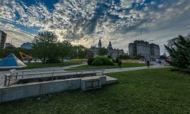
We stayed in Hong Kong for 4 days and other than checking out some viewpoints, we explored the city. There’s a very well organized metro system which makes getting around the city quick and easy. The fares depend on how far you’re traveling on the metro and you can check on the machines which can be set to English. We stayed in the Causeway Bay area which is bustling with lots of shops and restaurants. It’s also a short ride on the metro to Central where there are more malls among many skyscrapers. There is also a lively nightlife in Central with many bars and clubs in the area. Central also has ferries to cross the bay or for a day trip to Macau. Ferries to the mainland at Tsim Sha Tsui cost 3.70 HKD. At Tsim Sha Tsui, there’s a nice boardwalk called the Avenue of the Stars which goes along the bay. It’s a good spot to catch the sunset but we decided to catch the sunset at the Sky 100 observation deck in the International Commerce Center building. We bought our tickets for 135 HKD each and found that it’s cheaper to buy online rather than at the ticket office. Back on the Central side, there is also an Observation Wheel at the AIA Vitality Park which costs 20 HKD each. Overall, Hong Kong is a beautiful city that can be explored at your own pace via public transport.


Victoria Peak
This viewpoint is easily accessible via a funicular and its cheaper to buy tickets online. You get great views on the journey up to the peak and once at the destination station, there are several viewpoints. There are also some shops and restaurants there as well as the Madame Tussauds wax museum. From the station, there is another viewpoint along a trail that goes down the mountain which is a short 10-minute walk away. After taking some pictures there, we followed Google Maps for the Victoria Peak viewpoint. We got a bit lost and ended up at Victoria Peak Pavillion which was also a nice viewpoint. We then had to make a bit of a U-turn to get to Victoria Peak. The route is mainly along narrow roads with a couple of cars occasionally passing by. The last 5 minutes of the walk is along a dirt path going through trees and bushes. Once at the top, you get a great view of the city and the bay. The way back down to the station took us about 25 minutes so it’s not that far away.


Suicide Cliff
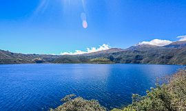
Another hike to a viewpoint is the infamously named Suicide Cliff. Although the path can be a little treacherous, it’s a fairly straightforward hike up to the viewpoint. There are several trails to the viewpoint and we chose to do a long one starting at City One metro station. We followed the directions on this site and they also have a handy Google Maps route. It’s a scenic hike with several views of the city along the way. From City One, we walked along the road towards Lion Rock Country Park. Once inside the park, there is a dirt trail going through trees. There is a small stream along the way to fill up your water bottle if you have a filter. It was very hot when we went with temperatures reaching 34 degrees. The route goes through Kowloon Peak Viewpoint which has great panoramics of the city. It’s possible to get a taxi/Uber here if you’re not into hikes. From this viewpoint, the route continues into the mountain and there is a warning sign saying it’s not safe. This is when the hike gets more difficult as the trail goes through overgrown grass and bushes. I was wearing shorts and got a couple of cuts from the bushes. Eventually, the trail leads past some antennas of the radio station and arrives at Suicide Cliff. The views of the city’s skyline from here are amazing. Overall, the hike was very tiring taking about 4 hours and 30 minutes to get to the top but with rewarding views. It was then another hour to go down to the main road. We were looking to get an Uber but it was about 5.30 PM now and the traffic was horrendous. So we decided to walk another 30 minutes to Choi Hung metro station to get back to our hostel.


